|
Backpacking the Maze (Canyonlands, Utah)
|
 |
| The Maze District of Canyonlands National Park is at the far end of a dusty dirt road. I had been there before, on several occasions, and had also driven the tire-busting narrow rocky roads Under the Ledge, down the Flint Trail and onwards to the Maze Overlook. While beautiful in its own right, driving through the Maze had still left in me that hollow yearning for an opportunity missed, for sights unseen in the dust cloud of the Jeep, for absolute silence left unsavoured, blotted out by engine noise. More than ample reason for me to return for another look. This time though (September 2009), I vowed to leave the Jeep behind up on the rim, and to explore the Maze on foot, backpacking from one scarce water source to the next. | |
|
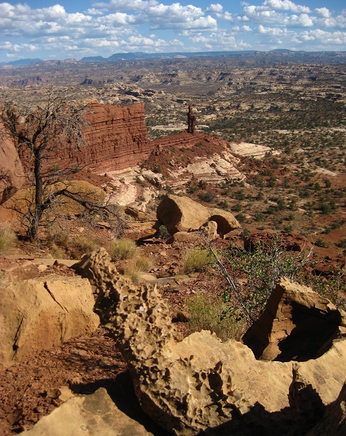
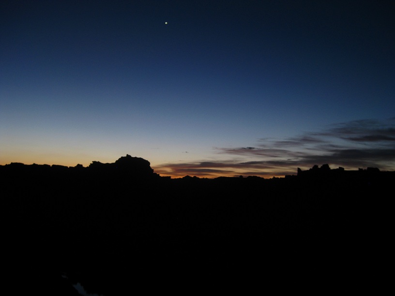
Planning and Preparation People who normally venture down into the Maze do so by Jeep, and have a strong propensity to stay within easy reach of the cold beer and warm water carried in their vehicle. As such, information on the exact location and reliability of natural water sources in the Maze turned out to be surprisingly hard to come by. From afar, over the phone, the National Park Service (NPS) didn't want to tell me much. I can't blame them, I guess they had their fair share of hikers who boldly marched off into the backcountry, only to die of thirst twenty paces away from a water source, without ever finding it. But the location of water sources, no matter how seasonal and ephemeral, was vital for me to plan my route through the Maze. After several days of Googling, studying maps old and new, and even reading the diaries of Miners and Cattlemen like Ned Chaffin who once had roamed this region, I ended up with a list of eleven possible water sources. Only three of them - the puddles in the canyon bottom below Maze Overlook, Lou's Spring, and of course the mighty Colorado River - were known to have water with some degree of certainty. These three points were about 15 miles from each other, a good day's march in this rugged terrain. If the water source I hiked to turned out to be dry, it would mean hiking back to the last good source, making it a 30 mile trek. With daytime temperatures still climbing into the 90s in September, I estimated that I would have to carry about 8-10 liters to be on the safe side: Too much weight to still enjoy the hike. I therefore planned for two scenarios: If conditions turned out to be exceptionally dry, I would hike the Flint Trail, then through Ernie's Country down to the Colorado and back largely the same way. If conditions were wet, I would hike a full loop, through Ernie's Country to Spanish Bottom, via Pete's Mesa to the Maze Overlook, and then via the badly misnamed "Big Water" canyon back to the starting point. The two options are shown on the map, with the red line marking the leg through Ernies Country common to both options. Before we get to the hike itself, a WARNING is in order: This route, especially the stretch through Ernies Country, is about as remote and as far away from help as you can get in Utah. While I hiked the entire stretch solo, completely on my own, I am used to serious hiking in this remote area of Utah. Even so, I was carrying a Spot Messenger, and used the device to allow a friend back home to keep watch over my status and progress. In spite of all the preparation and precaution, things can go wrong, and even if you manage to signal for help, it will take any rescue effort a day or two to get to where you are. If you are not self-reliant enough to deal with such a situation or the consequences, don't attempt this hike. The Hike - Through Ernies Country to Spanish Bottom 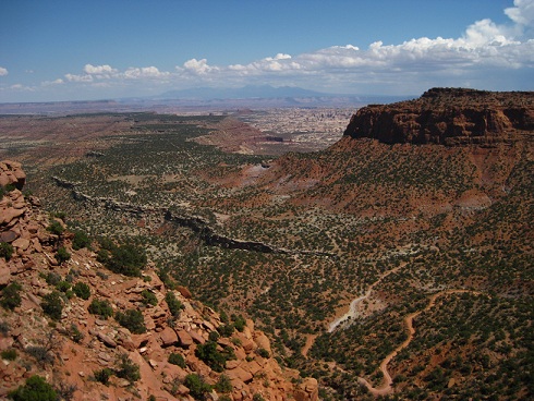 Since I planned to spend the first night up on the rim, at The Neck, I knew that I had ample time to get there, and thus took a late leisurely lazy breakfast at Blondie's in Hanksville before heading out onto the dirt track leading to Hans Flat Ranger Station and the Maze. I caught the ranger right when he wanted to leave for his lunch break, but I guess he doesn't get all that many visitors out there - he didn't hesitate one second to turn around and unlock the station again, to let me in. NPS backcountry permits are accompanied by the customary lecture on The Crust, The Cathole and The Creed ("Leave no trace"). After my many trips through the region, I pretty much know it by heart, but I certainly do understand why it is delivered, and in any case it is part of the ritual to get under way. I was giddy with hiking fever by that time. Once thru the lecture, the ranger pulled out the patrol blotter to verify what information they had on water availability in the springs and seeps that I asked about. Things didn't look good, the summer rains had been thin and late this year, and even the most reliable spring was mentioned in the blotter as "going dry". And that information was one month old - nobody had been there since. Well, I wanted my backcountry permit anyway - a look-see couldn't hurt. Driving out to my campsite for the night, over a dirt track too rough to go fast, I had plenty time to ponder the best approach, given the new information. It was 2:30pm when I got to the top of the Flint Trail, and I stopped to look down (picture on the right).
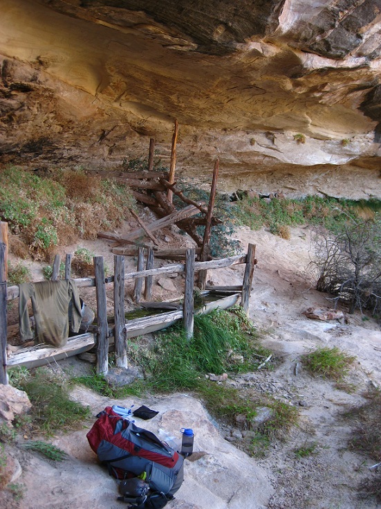
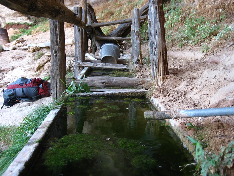
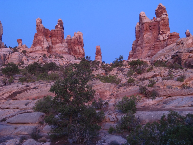
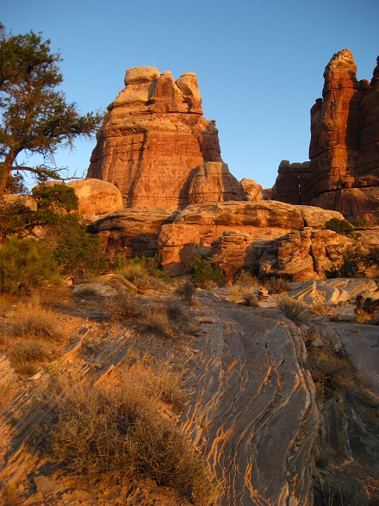
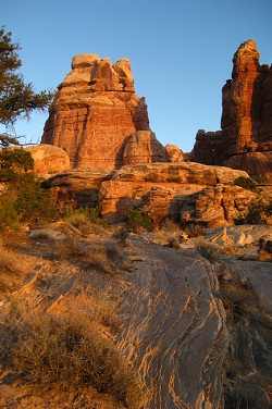
My first water source, Lou's Spring, was about ten miles away. Antsy to find out if there was any water to be had at Lou's, or whether my hike would be busted already on day one, I decided to ditch the first night next to the Jeep in favor of a quick dash down into the canyon. The first part would follow the Flint Trail down and out to China Neck, then down the Golden Stairs to reach the Maze bottom near the formation called "Mother and Child", from where it would be another mile or two down to Lou's Spring. Since it was far from certain that Lou's would have any water, I opted to carry a plastic gallon jug of water in my hand in addition to the water in my backpack. The gallon, left behind hidden right on top of the Golden Stairs, would ensure my safe return even if I found Lou's completely parched. Golden Stairs are neither very golden nor very stairs, but pretty much the only way to get down over the cliff safely. The trail drops steeply through a notch, then follows the talus slope back to the west for what feels like forever, before dropping again in a rubbly slip-slide down to the flats above Range Canyon. By the time I got down there, it was 5:30 and the shadows cast by the rock formations were getting longer. Time to find the water - if any was to be had! There is a marked trail of sorts (cairns) that leads off into Range Canyon and Ernies Country, but without knowing where Lou's Spring is, you would walk right past it. Following the lead of my GPS to a waypoint researched back home, I found Lou's Spring tucked away in the shade of a massive sandstone overhang, and not only did it have water in the catch trough, there was even fresh water dripping in at a rate of about three drops per second. There's nothing as beautiful in the desert as the music of dripping water - pure Utah Backcountry bliss. I hadn't been as happy in a long time! -- Lou's Spring is named after Lou Chaffin, the father of Ned Chaffin whose memoirs I had read in preparation of this trip. As Ned's story goes, the conservation corps improved this spring in 1935 and placed the half-barrel water catch which still is in working order today, seventyfive years later! After using my trusty Katadyn filter and filling up my bottles and my belly, I left the spring to the wildlife and retreated into a canyon nearby to set up my tent for the night.  Come morning, I got up early, and after a quick breakfast of hot oatmeal to bane the night's chill from my bones, I ventured back to Lou's Spring to re-fill all my bottles for the long and dry trek ahead. Ernies Country, which lay ahead, is pretty unforgiving. A lot of sand, a tricky labyrinth of canyons, and above all: no reliable water at all. Venturing out there was a calculated risk, I knew that beyond Ernies lay the Doll House, and from there a maintained trail led down to Spanish Bottom and the Colorado River. Nobody ever heard of the Colorado running dry, so I expected to be OK even if hiking across the Ernie sand flats would eat up a lot of the water that I was carrying. Only one way to find out: on I went. There is a marked hiking trail of sorts that leads through Ernies Country, but the real sights are off the trail to the north, in the area called "The Fins". Thus - meandering back and forth - it took me quite a while to get anywhere. Clell's Seep, a water source on the way, named after Ned Chaffin's brother, turned out to be almost dry, it produced about three drops per minute. Enough to survive on in an emergency, but by far not enough to try to re-fill any bottles. And on I went, over sandstone ridges, into dry washes, back up onto a ridge, and repeat. The complete silence I had hoped to find on this hike was thick and buttery around me, I could literally feel it part where I went and close up again in my wake. I don't know any other experience that even comes close to the exhilaration of hiking alone through a remote corner of Utah.
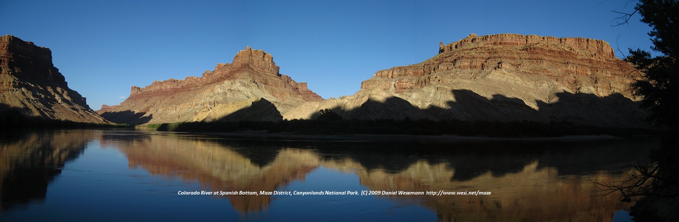
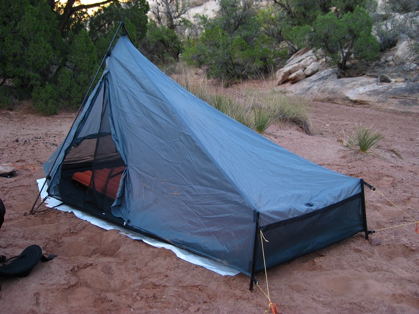
By noon, I reached the Dollhouse. This is where the Ernies' trail re-joins civilization, so to speak, because the Doll House is one of the established backcountry camp sites in the Maze. Driving there takes almost as long as it took me to hike there, though. The camp site was deserted, nobody around. As is wise and customary in the desert, I found myself a large boulder and plunked down in its shade to sleep through the midday heat. Waking up from my slumber at 4pm, I realized that I was down to my last liter of water. If the trail down from the Doll House to Spanish Bottom turned out to be blocked or impassable for some reason, I would be in trouble. Not knowing didn't let me sleep further, so I started my descent. The trail was steep - very steep - but perfectly all right. One hour later, I languished at the shore of the mighty Colorado River, and swapped stories with two Kayakers who had come paddling down the river just when I got there. They also planned to spend the night, and expected a motor barge to come and pick them up in the morning to bring them back upstream to Moab. We sat down on the high shore and watched the reflection of the sunset paint the canyon walls. The Gear Hiking in the desert, I always take careful note of which piece of gear works well, and which doesn't. Over time, this has given me a pretty decent set of desert backpacking equipment. I own to variants of gear: One is the extremely simple 50's style blanket pack that I learned to love and cherish on my trek with Boulder Outdoor Survival School and that I used on last year's hike through Happy Canyon. The other is a Venturi 40 backpack, which is small enough to be light, and just big enough to allow for weeklong trips. On this trek, I carried the latter, and had it stuffed with a Sublite Tarptent, an Exped Synmat 7 DLX, and a REI Travelsack. This choice of overnight gear worked out extremely well. The Tarptent is roomy even for my 6'4", is very well ventilated, and did a very good job at keeping the bugs out when I camped at Spanish Bottom near the water's edge. The REI Travelsack is unbeatable at 60$, maybe a bit on the weighty side, but comfy and roomy. You might think the Exped mat, which weights in at 1kg, doesn't quite fit into the set ... but I'm a side sleeper who tosses and turns throughout the night, and I have long since learned that 500grams or so more weight for the mat is amply paid for with good sleep and better rest. The four-season mat also provides supreme insulation from the ground, and allows me to get away with the cheapo Travelsack as sleeping bag. In case things get unexpectedly cold, I always carry my long sleeve thermals though - basically as part of my survival gear: I even carry my thermal longjohns in the backpack when I go for a dayhike in the Sonora in July :). Other notable mentions of stuff that works well in the Maze: sand tent anchors, from REI if I remember correctly. There's rocks aplenty, no chance for a flimsy tent stake, but packing a rock into the tent anchor baggie worked every time. I also liked my Platypus water bottles a lot - no way would it have been possible to squeeze seven liters of Nalgenes into my small Venturi backpack, but five liters of Platy bottles fit just fine, and complemented the two Nalgenes that I carried in the pouches outside of the pack. I wouldn't venture into the desert with only plastic baggie style Platypus bottles - there's just too much abrasive and spiny stuff out there - but the Platties are perfect to complement more sturdy bottles, and boosted my water carrying capacity without taking up a lot of space. In terms of food, I sure should know better by now, but again brought too many energy bars and too little salty stuff. All the Ramen packages that I carried were gone at the end of the hike, but five energy bars remained. The Hike Back 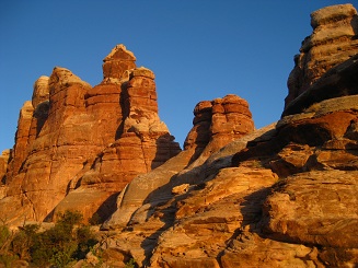 In view of the very little water that I had found on the way in to Spanish Bottom, taking the longer return route via Maze Overlook was risky. While chances were good that I would find water in the canyon off the Harvest Scene panel, climbing the cliff to Maze Overlook would use up a lot of that water, and I had no doubts that the 12 miles from the Overlook along the dirt road to the bottom of Flint Trail would be completely dry. Doable, sure, but what keeps me hiking alone in the backcountry is that I don't take unnecessary risks. I had been to the Maze Overlook and Harvest Scene before, and thus opted for the safe variant: I would circle back, roughly along the dirt road, to the bottom of Golden Stairs, and spend another night at Lou's Spring, before climbing back out. Decision taken, I started cooking dinner on the high bank of the Colorado at Spanish Bottom, and gratefully accepted the offer of the two Kayakers to refill my bottles from their supply of drinking water. They were carrying what must have been at least a 10 gallon canister in their boat, and had ample water left. Their generosity spared me the effort of pumping seven liters of Colorado silt through my poor little Katadyn filter. Still hungry after my Ramen dinner, I ripped into a baggie of tuna, and idly wondered what vile chemical they put in there to keep it from spoiling. I have carried Starkist baggies to every corner of the desert, through the Grand Canyon, across the Sonora, even into the merciless oven of the Mojave, and not once did it spoil on me. This can't be tuna, really, it must be some sort of alien skin graft.
Even though I didn't have any alarm clock, I managed to get up bright and early at 4am, as I had intended. I wanted to climb the 1000ft ascend from Spanish Bottom before the sun hit the rock face in full glory. My headlamp helped, and I got back up to the rim below the Doll House at the mere crack of dawn. The light soon improved though, and I was treated to a morning light spectacle in the Doll House that few people ever behold. In spite of my lingering to take in the sights, I made short work of the trail back to Lou's Spring. I got there around 1pm, right when the midday heat started to make hiking uncomfortable, and again slept through most of the afternoon. Waking up at 4:30pm, I had two options: stay put, or hike out. After the long nap, I was bursting with energy, so the choice was an easy one: I refilled my bottles and headed out. Two hours later, the sun just touching the horizon, I was back at the top of Golden Stairs and retrieved my water cache. I didn't need it, but neither did I feel like carrying it, so I donated the gallon of Arrowhead's Finest to a gnarly old juniper tree that seemed appreciative of my gift. The way back to the top of Flint Trail took me longer than I had thought it would, and it was pitch black dark by the time I reached my car. I wasn't very tired though - there is nothing like sleeping off an afternoon in the shade to keep me alert at night. After only brief hesitation, I tacked on the two hours plus of driving the sandy dirt road to Green River, all in complete darkness. I sure like sleeping in my tent and eating Ramen for dinner, but if I have the choice to eat a burger at West Winds Truck Stop in Green River after hiking for three days ... well, the burger wins :). The entire hike was 44mi/71km and took me about three days (with two nights out there) to complete. © 2009 Daniel Wesemann (back to travel overview) |
|